
Along with Rustler Gulch, we recommend adding the Frigid Air Pass loop or 3 Pass loop to your bucket list (there are so many to choose from). Experience epic wildflower blooms throughout the summer as this hike takes you up above tree line for some truly spectacular panoramas. From Frigid Air Pass, the south face of South Maroon Peak towers over Fravert Basin and you can even see Mt. Crested Butte in the opposite direction.

| Frigid Air Pass Loop | 3 Pass Loop w/West Maroon | |
|---|---|---|
| Highlights: | Wildflowers, Mountain Vistas | Wildflowers, Mountain Vistas |
| Difficulty: | Strenuous | Strenuous |
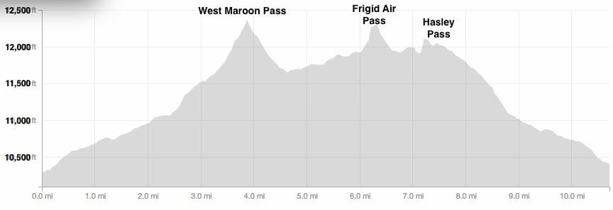
| RT Length: | 9.3 miles | 10.8 miles |
| Approx. Time: | 5 hours | 6 hours |
| Elevation Gain: | 2,722 feet | 3,214 feet |
| Max Elevation: | 12,400 feet | 12,490 feet |
| Trailhead Elevation: | 10,432 feet | 10,432 feet |
| Travel Time to TH: | 45 minutes | 45 minutes |
Click photos to view multi-season gallery


Directions
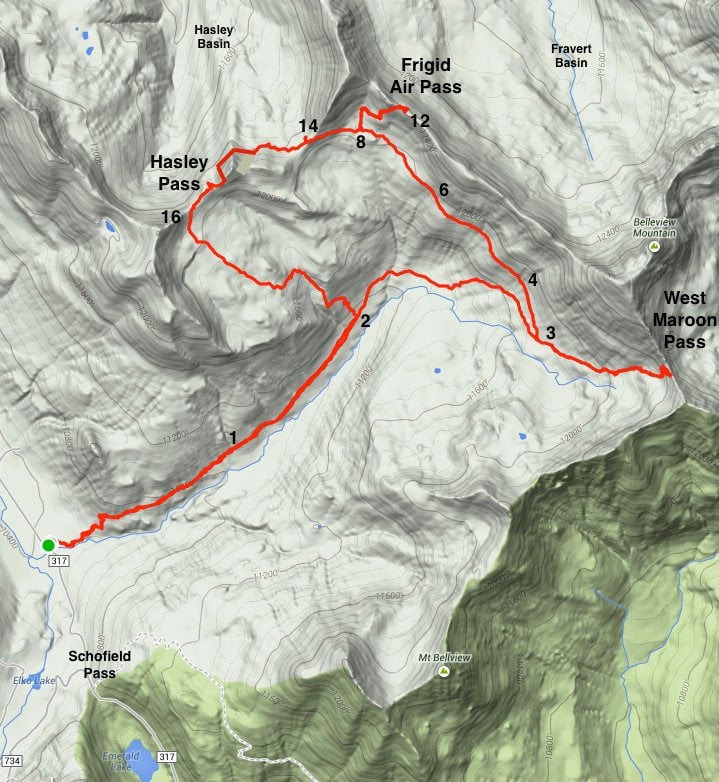
SUV recommended: From the Town of Crested Butte, take Gothic Road (Route 135) north 14 miles over Schofield Pass. Shortly after the pass there is a large parking lot and the trailhead is on the right side. Map (continue past the marker on the map on rte 317 toward the trailhead/parking lot)
Route
Start off with the route description from the West Maroon Pass hike. Follow the directions up the valley [1] and to the right at the small signed Hasley Basin junction [2]. At the next signed junction for Frigid Air Pass [3], take a left continue on the mellow ascent back in the opposite direction (or hike up West Maroon Pass first for the 3 Pass Loop). The next sign post indicates where the turnoff is for Frigid Air Pass [6]. Take a right turn and head up toward the ridge line. This is where the trail gets much steeper as you reach the maximum elevation for this hike. Near the top you'll be able to see Mt. Crested Butte off to the southeast, poking above the ridge on the opposite side of the valley [11].
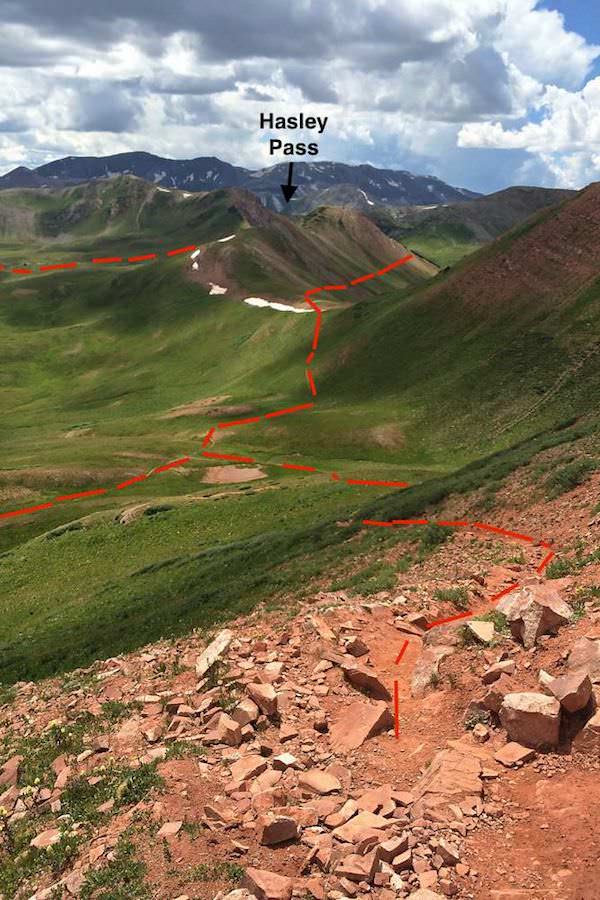
Now get ready to be awestruck! As you crest the ridge, Fravert Basin appears suddenly and South Maroon Peak is looming directly ahead [12]. This is a great place to take a breather and relax with a meal. Standing on this pass, you can see much of the remaining route, with Hasley Pass off in the distance [9].
Trace your steps back down to the signed post, and take a right toward the next saddle. Hike up and over into Hasley Basin [14] with grand views of Snowmass Mountain on the other side of the valley [15]. If you're lucky, you may see (and hear!) a flock of sheep.
The trail starts to fade out here. Your goal is to get around the second large hill and back up to the second saddle, which is Hasley Pass [9]. A large talus slope cascades down the northwest side of the second hill. Hike across the slide and the trail reappears strongly about .3 miles below the Pass. Be sure to follow it up and feel free to take another breather. See your progress as you look back from the pass [16]. From here it's all downhill through tall wildflower meadows on a solid trail. There are great views of West Maroon Pass down the valley. Both passes can be hiked individually, but we prefer to loop them. You can also start with hiking West Maroon Pass (highly recommended) to make this a grand 3 Pass Loop.

Weather in the mountains can change very fast. During the summer months it is common to have thunderstorms developing during the afternoon in the high country. Check the weather forecast before you go. Keep your eyes on the clouds and know when to turn back

For longer hikes its a good idea to carry a few extra things in your pack. Make sure to bring extra food and water, rain gear, a map or gps, sun protection, and a flashlight in case your hike goes late. More information on what to pack can be found here.

- Try and use restrooms at lower elevations or practice LNT "when nature calls" (more info here)
- Trash and human waste can take years to decompose in an alpine environment, so be prepared to pack it out

Please don’t pick, cut, or walk on wildflowers or other plants. Removing wildflowers from the wild can adversely affect pollinators and other animals that depend on that species for food and cover and affect the flowers long-term survival in that location.
Click photos to view multi-season gallery


Trail Map & Profile

![[9]](https://travelcrestedbutte.com/wp-content/uploads/9.jpg)