First things first: Add Rustler Gulch to your bucket list. There aren't many hikes that can compete with the amazing variety and abundance of wildflowers you'll find here. This is one of those rare treats that occur in a very short summer window (late July, early August). In addition to the vivid colors and fragrances, this valley also treats you to numerous waterfalls and mountain views.

Sustainable Trail Use
This trail and many others like it are maintained by the Crested Butte Conservation Corps. From picking up trash to trail maintenance to poop removal, they do it all and keep our backcountry pristine. Please help support them with a tax-deductible donation (501c3).
| Highlights: | Wildflowers, Mountain views |
| Difficulty: | Moderate |
| RT Length: | 7 miles |
| Approx. Time: | 4 hours |
| Elevation Gain: | 1850 feet |
| Max Elevation: | 11,400 feet |
| Trailhead Elevation: | 10,250 feet |
| Travel Time to TH: | 45 minutes |
Click photos to view multi-season gallery


Directions
From the Town of Crested Butte: Take Gothic Road (135) north past Mt. Crested Butte for 4.3 miles. Bear right past the Snodgrass Trailhead parking lot and descend into the East River Valley for another 6.5 miles past the town of Gothic until you reach the signed Rustler Gulch road. Turn right and drive this rocky road 0.2 miles to the East River (check the depth). Cross the river [0] and park on the right side, or continue driving on a steep narrow road for another mile to the TH sign. There is limited parking for 5 to 6 SUVs. Cars can make it to the East River (although the road is rough the last 0.2 miles). A high clearance SUV is recommended to cross the river and go up the steep road to the TH. Map
Route
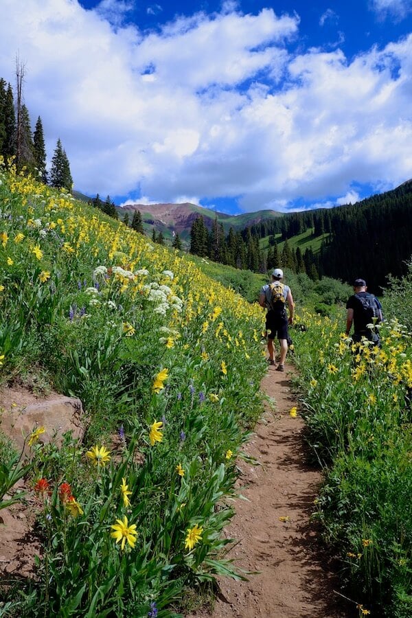
From the start, you will be surrounded by tall wildflower meadows [2]. Look behind you for fantastic views of Gothic Mountain [1]. There is a creek crossing just past 3/4 miles in, which may get your shoes or boots wet. For a drier alternative, check a hundred yards downstream and find a big tree that crosses over. Find another creek crossing in about 3/4 of a mile. The path dries out ahead as it ascends some rocky trail toward the jagged red rocks ahead.
Follow the trail as it curves into the gulch and parallels the stream below. Take in the views of the 13,000 ft Precarious Peak looming at the end of the valley [11]. Continue ascending and notice the wildflowers species changing with altitude. Near the turnaround you'll pass some old mining equipment [15], now reclaimed by nature. The waterfalls at 3.5 miles are a great point to take some photos and head back down. The trail continues for a short bit beyond the waterfalls. If you're feeling ambitious, continue up for greater views of the valley below.

Please don’t pick, cut, or walk on wildflowers or other plants. Removing wildflowers from the wild can adversely affect pollinators and other animals that depend on that species for food and cover, and affect the flowers long-term survival in that location.
Click photos to view multi-season gallery


Trail Map & Profile


Enjoying this trail? Help support the people who maintain it. Donate to the Crested Butte Conservation Corps.
Featured Lodging
At Crested Butte Lodging & Property Management, they understand the quality of lodging can make or break your vacation. They have carefully evaluated and inspected each property and have categorized our accommodations to further help you make your lodging selection. They want you to come to Crested Butte, Colorado to relax and have fun – not hassle with your accommodations.