
Gunsight Pass follows an old mining road as it makes its way from Gunsight bridge all the way up to Scarps ridge. This mellow but long route is great for training on the bike or a close to town hike! Did we mention the summit of Red Lady is just a short jaunt from the top of the pass?

| Trail: | Gunsight Pass | Red Lady Summit |
| Approx. Time: | 5 hours RT | 6 hours RT |
| Difficulty: | Hard | Very Hard |
| Elevation Gain: | 3,150 feet | 3,437 feet |
| Highlights: | Aspens, Wilderness, Wildflowers, Mining | Aspens, Wilderness, Wildflowers, Mining |
| Max Elevation: | 12,087 feet | 12,392 feet |
| RT Length: | 14 Miles RT | 15 Miles RT |
| Trailhead Elevation: | 8,955 feet | 8,955 feet |
| Trailhead: | Gunsight Bridge | Gunsight Bridge |
| Travel Time to TH: | 15 Minutes | 15 Minutes |
Click photos to view multi-season gallery
")


")


Directions
From the Town of Crested Butte: Take Gothic Road (135) north 0.8 miles to Slate River Road (734). Turn left and drive 3.6 miles before taking left on 739A. Park on the left side of the road next to the parking blocks.
Route
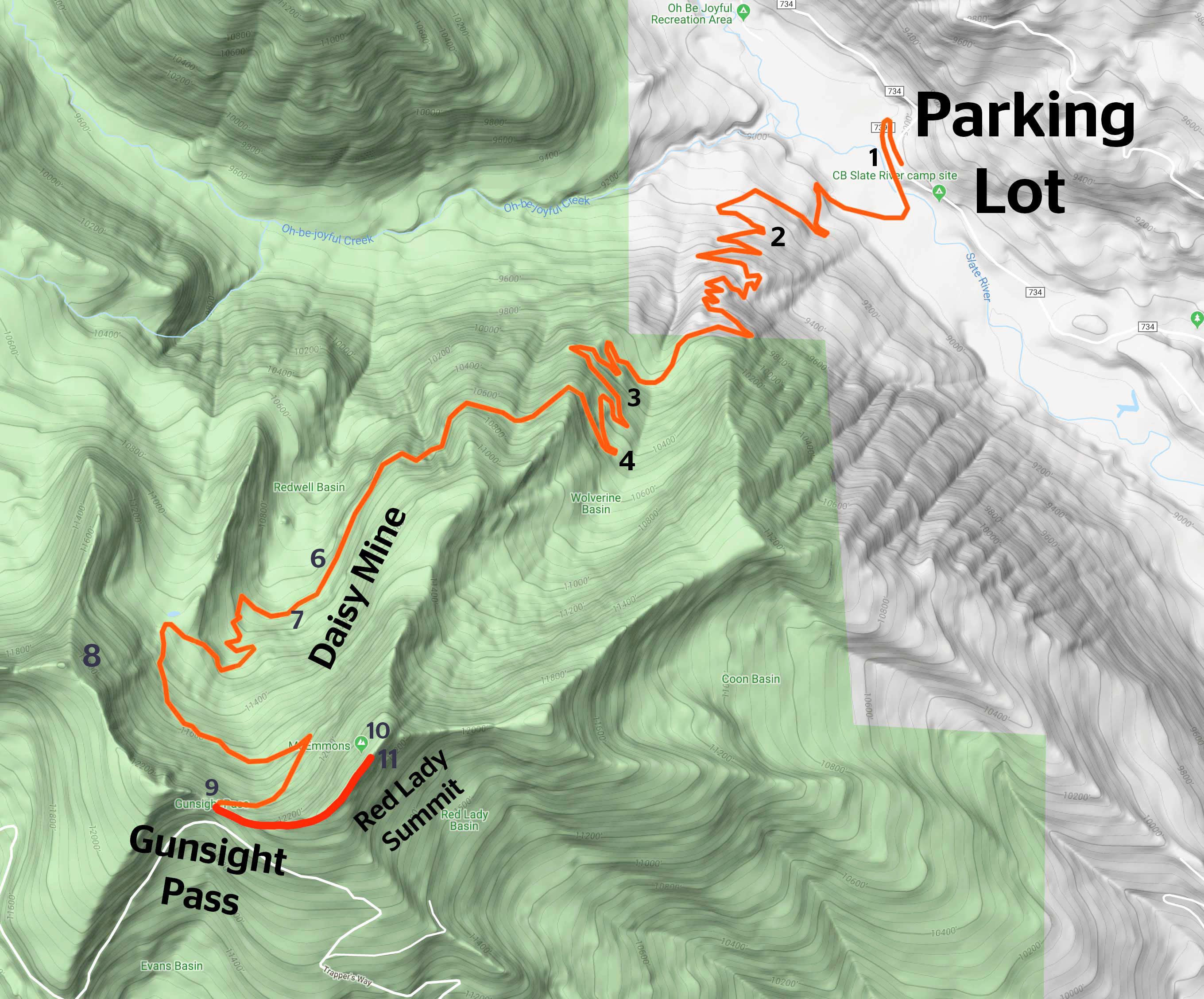
From the parking lot walk down towards the Slate River. Cross Gunsight Bridge [1] and continue on to the right up Gunsight Road. Be sure to stay to the right (left brings you onto the Lower Loop trail system) and follow the wide road into the trees and up a decent slope. Stay on the main road (there are a lot of other exit trails to avoid) as you ascend for a while and gain some views [2]. Follow the road [3] for approx. 4 miles as it switchbacks up into Redwell Basin. Be on the lookout for wild raspberries [4] [5] along this entire stretch of road.
As you emerge into Redwell Basin [6] stay on the main road. Right takes you to Peeler Lakes. Pass the remains of the Daisy Mine [7][8] on your left. Continue along until you find a road closed sign. From here it's just another .75 mile climb to the top of Gunsight Pass! [9] Gunsight Pass is a reward in itself! Take in the views back down the valley. Walk around the locked gate [10 looking back] to continue the final ascent to the summit of Red Lady (Mt. Emmons). It’s just another 15-20 minute hike from here on a well-defined trail. You’ll be greeted by prayer flags [11], and unobstructed views of Crested Butte at the top [12].

For longer hikes its a good idea to carry a few extra things in your pack. Make sure to bring extra food and water, rain gear, a map or GPS, sun protection, and a flashlight in case your hike goes late. More information on what to pack can be found here.

.Practice 'leave no trace' principles. Trash and human waste can take decades to decompose in an alpine environment. Pack it in, pack it out with all trash. There is a restroom at the lower parking lot. Try and use it before your hike. More information on how to handle waste in the backcountry can be found here.

Please don’t pick, cut, or walk on wildflowers or other plants. Removing wildflowers from the wild can adversely affect pollinators and other animals that depend on that species for food and cover and affect the flowers long-term survival in that location.
Trail Map & Profile

Enjoying this trail? Help support the people who maintain it. Donate to the Crested Butte Conservation Corps.
Featured Lodging
Crested Butte Lodging
Vacation Rentals all around CB
reservations@crestedbuttelodging.com
At Crested Butte Lodging & Property Management, they understand the quality of lodging can make or break your vacation. They have carefully evaluated and inspected each property and have categorized our accommodations to further help you make your lodging selection. They want you to come to Crested Butte, Colorado to relax and have fun – not hassle with your accommodations.

![[3]](https://travelcrestedbutte.com/wp-content/uploads/2019/09/IMG_2580-4.jpg)
![[6]](https://travelcrestedbutte.com/wp-content/uploads/2019/09/DJI_0091-Pano.jpg)
![[11]](https://travelcrestedbutte.com/wp-content/uploads/IMG_7680.jpg)
![[12]](https://travelcrestedbutte.com/wp-content/uploads/IMG_7690.jpg)